Weather:
- Ha Noi 33oC
- Da Nang 28oC
- Ho Chi Minh 33oC

Lê Hương
National parks with abundant greenery and diverse flora and fauna act as lungs for many regions and provide a paradise for nature lovers.
Let’s explore some beautiful national parks in northern Việt Nam.
Tam Đảo National Park
Location: The park is located at the end of Tam Đảo Mountain Range, covering nearly 35,000ha (over 26,000 of which is forest) in three provinces of Vĩnh Phúc, Thái Nguyên and Tuyên Quang, which is 75km to the north of capital Hà Nội (around 2- hour drive).
The park includes over 20 mountain peaks of at least 1,000m above sea level each. The highest one is Mt Tam Đảo Nord, 1,597m in height.
How to get there:
By motorbike: From Hà Nội, you depart in the direction of Thăng Long – Nội Bài, to Phúc Yên, and travel towards Vĩnh Yên.
By bus: Take bus No 58 to Mê Linh Plaza, change to Bus No 1 to Vĩnh Phúc. Take bus No 7 to Tây Thiên and ask the driver to stop at Tam Đảo National Park. From there, you can take a motorbike taxi to the park.
You can also choose Nhật Nam or Tiến Thịnh buses at a price of some VNĐ150,000/pax.
Accommodation: You can camp in the park or rent a room in Tam Đảo Town. In the first case, remember to prepare sufficient equipment and register with the forest rangers. You can also register for a camping tour there.
Other notes:
The ideal time for visiting the park is in spring and summer.
Popular destinations include Television tower, Bạc (Silver) Waterfalls, Bà Chúa Thượng Ngàn (Mountain Goddess) Temple, and the pine forest.
Trekking routes here are fairly primitive with no path in many sections, which are covered by dense forest. So it’s better to trek in a group or with a guide. You can join trekking tours of the park at a price of VNĐ500,000-800,000.
Ba Vì National Park
Location: The park is located some 60km to the west of Hà Nội and is a familiar picnic site for Hanoians.
How to get there:
By bike: Go straight on Thăng Long National Highway up to Hòa Lạc Overpass, keep straight on Yên Bài Road, passing the Việt Nam National Village of Culture and Tourism on the right. When you go to the end of Yên Bài Road, turn left and keep going straight for 20km. The park will be on your left.

By bus:
There are no direct bus from Hà Nội to Ba Vì National Park. You can take Bus No 214 from Yên Nghĩa Bus Terminal to Xuân Khanh or Bus No 71 or 74 from Mỹ Đình Bus Terminal to Xuân Khanh, which is 5km from the park. Then, you can take a motorbike taxi or car to the park.
Accommodation:
You can camp during the daytime in a clear site near the old church in the park. If you want to camp or stay at hotels overnight, you should camp at Tiên Sa Lake, rent a room at Ba Vì Resort or a private pine forest near the Cactus Garden.
Other notes:
You should come here between April and October, when the scenery is beautiful with a fresh atmosphere. But in November can you see wild sunflowers in the mountains.
From the gate of the park, you can reach sightseeing spots by bike, car or on foot.
From section 400m up, buses of over 30 seats are prohibited.
If you want to trek up, you can park bikes or cars at the parking lots, which costs VNĐ3,000/bike and VNĐ20,000-25,000/car.
You can visit the Cactus Garden, old church ruins, Thượng Temple and President Hồ Chí Minh Temple.
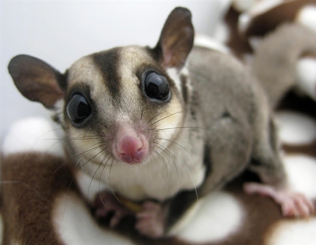
The park hosts over 1,000 species of plants and trees, 200 of which are valuable medicinal plants and wood trees. The park is home to 45 species of mammals, 115 species of birds, 61 kinds of reptiles, and 27 kinds of frogs, many of which are listed in the Red Book of Việt Nam.
The park is situated in high mountain ranges running in a northeastern – southwestern direction, which include Mt Tản Viên, 1,296m above sea level, and Mt Ngọc Hoa, 1,131m.
There are easy routes lasting for some two hours from an altitude of 1,100m down to 400m, where participants can trek on various distances of 5km, 10km, 20km and more.
Viettrekking company offers a 1-day tour that starts in Trung Temple at an altitude of 350m and enters the forest from the temple after visiting magnificent Buddha statues. The trekkers will stop for lunch at noon and finish their route at around 4pm at an altitude of 1,100m.
Cát Bà National Park
Location:
Situated in Trân Châu Commune, Cát Hải District, the park is some 60km from Hải Phòng City and some 15km from Cát Bà Town. The park has always drawn tourists as it is among the best in Việt Nam with rich fauna and flora.
How to get there:
From Hà Nội, you can ride a bike or take a bus to Hải Phòng City.
By bus: Take the bus from Gia Lâm Bus Terminal or Yên Nghĩa Bus Terminal to Hải Phòng at a cost of some VNĐ100,000-120,000/ticket.
By bike: Drive 120km on National Highway 5B to Hải Phòng.
From Hải Phòng to Cát Bà: You can take a ferry from Đình Vũ Wharf or a highspeed boat to Bính Wharf.
From Cát Bà Town to Cát Bà National Park: You can go by bike or car for 15km; or take a taxi at a cost of some VNĐ200,000/one-way trip.
Accommodation:
To have more time to explore the park, most visitors choose to stay overnight in Cát Bà Town and return to the park the next day as the distance is fairly short and the service in the town is better. Yet you can stay overnight right inside the park; either by renting a room there or registering for a camping service.
Other notes:
The best time to visit the park is between April and October.
Popular routes:
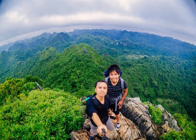
4-8 hour trekking route: include mountain climbing, trekking: Fro Pond - Việt Hải, Mây Bầu – Military Cave, Kim Giao – Mé Cồn – Tùng Di.
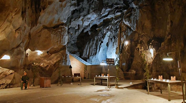
2-3 hour route (for motorbike, bicycle, car and trekking): Kim Giao forest, Mt Ngự Lâm, Trung Trang Motto – Ủy Ban Cave.
The park possesses spectacular routes of medium level for trekkers. It is also home to most of white-headed langurs existing in the world. VNS